Hello,
I am bootstrapping an Air Traffic Control simulator to develop it in Ada. I am going to be re-doing my previous work in C of this project and need to be able to load from the database the waypoints, planes, airports, runways, etc. It should be easy to modify for quick iteration. The amounts of data is not enormous and I do not need blazingly fast speed.
A critical point for me is that the loader should be relatively simple. For example, this is the parser library for my previous project, which you can see has few and small files at lib/: ZenitDS/lzconf: Custom config file library - Codeberg.org
This is one database file which I had previously and give as an example:
The next example will have different structure and content but I hope that it is clear what I mean
# RESOURCE_DIRECTORY/GCCC/atc/atc.zc

[ include
	display.cxo graph/cxo.zc
	display.cts graph/cts.zc
	display.gca graph/gca.zc
	display.twr graph/twr.zc
	display.rwy graph/rwy.zc
	display.mva graph/mva.zc
	display.obs graph/obs.zc
	display.cac graph/cac.zc

	display.st.SCT graph/state/SECTOR.zc
	display.st.SCTH graph/state/SECTORH.zc

	display.sct.gcts graph/sector/gcts.zc
	display.sct.gcxo graph/sector/gcxo.zc
	display.sct.gclp_n graph/sector/gclp_n.zc
	display.sct.gclp_s graph/sector/gclp_s.zc
	display.sct.gcnb graph/sector/gcnb.zc
	display.sct.gcac graph/sector/gcac.zc

	display.terrain.tenerife graph/terrain/tenerife.zc
	display.terrain.lagomera graph/terrain/lagomera.zc
	display.terrain.elhierro graph/terrain/elhierro.zc
	display.terrain.fuerteventura graph/terrain/fuerteventura.zc
	display.terrain.grancanaria graph/terrain/grancanaria.zc
	display.terrain.lanzarote graph/terrain/lanzarote.zc
	display.terrain.lapalma graph/terrain/lapalma.zc

	env.cfg ../env/cfg.zc
	env.ways ../env/ways.zc
	env.freqs ../env/freq.zc
]

[ positions
	[ tnfs
		[ mode TRACON ]
		[ display
			cts
			st.SCT sct.gcxo sct.gclp_n sct.gclp_s sct.gcnb sct.gcac
			st.SCTH sct.gcts
			obs twr rwy mva
			terrain.tenerife
			terrain.lagomera
			terrain.elhierro
			terrain.fuerteventura
			terrain.grancanaria
			terrain.lanzarote
			terrain.lapalma
		]
		[ range 35. ]
		[ filter "005/240 010/160" ]
		[ rings "10|28 02 40 N 016 34 21 W" ]
		[ center "27 56 06.2 N 016 38 09.6 W" ]
		[ frequencies
			[ TNF_SOUTH_APP ]
			[ UNICOM ]
		]
		[ atis GCTS GCXO GCLP GCFV GCRR GCHI GCLA ]
		[ waypoint
			GDV HIE LPC TFN TFS LRO FTV LZR LTE
			ESOPA LUFIR QITTI FEMMA LULUG YELBE
			ICAFU YEQAY BOXCO ARACO REMGI ODEGI
			MOROD LUCSI XANOS KUTUR COSSE PELIN
			LOMAS
			TS506 TS559 TS568 TS710 TS717 TS721 TS726
			TS731 TS742 TS744 TS746 TS748 TS763 TS765
			TS767 TS769 TS901 TS971 TS972
		]
		[ runway "7" ]
		[ taxiway ]
	]

	[ tnfn
		[ mode TRACON ]
		[ display
			cxo
			st.SCT sct.gcts sct.gclp_n sct.gclp_s sct.gcnb sct.gcac
			st.SCTH sct.gcxo
			obs twr rwy mva
			terrain.tenerife
			terrain.lagomera
			terrain.elhierro
			terrain.fuerteventura
			terrain.grancanaria
			terrain.lanzarote
			terrain.lapalma
		]
		[ range 35. ]
		[ filter "005/100 010/150" ]
		[ rings "10|28 28 58 N 016 20 30 W" ]
		[ center "28 35 00 N 016 20 00 W" ]
		[ frequencies
			[ TNF_NORTH_APP ]
			[ UNICOM ]
		]
		[ atis GCXO GCTS GCLP GCFV GCRR GCHI GCLA ]
		[ waypoint
			GDV HIE LPC TFN TFS LRO FTV LZR LTE
			BUNIX BASUX CANDE TESEL
			ARTEM MOROD COSSE BOXCO
		]
		[ runway "30" ]
		[ taxiway ]
	]

	[ gca
		[ mode TRACON ]
		[ display
			gca
			st.SCT sct.gcts sct.gcxo sct.gcnb sct.gcac
			st.SCTH sct.gclp_n sct.gclp_s
			obs twr rwy mva
			terrain.tenerife
			terrain.lagomera
			terrain.elhierro
			terrain.fuerteventura
			terrain.grancanaria
			terrain.lanzarote
			terrain.lapalma
		]
		[ range 55. ]
		[ filter "005/240 010/160" ]
		[ rings "5|27 42 28.1 N 015 21 34.7 W" ]

		[ center "28 00 00 N 015 23 12 W" ]
		[ frequencies
			[ GCA_APP ]
			[ UNICOM ]
		]
		[ atis GCLP GCTS GCXO GCFV GCRR GCHI GCLA ]
		[ waypoint
			GDV HIE LPC TFN TFS LRO FTV LZR LTE
			LOMAS ODEGI REMGI URQUI
			ECKOS ISLET DRANO THAIS NERVO ARTEM COLON
			LARYS RASEP KOPUD MOVAS QITTI
			ENETA LALTO TOMOS FALPU TISCA ADOKI CANDE
			MATUD SARWO ZUCRU KONDA PELIN
			DELAP ISORU TODKO LACOR LIFBI COCTO BAFEM
			XIBUS NIDES BETAN CANIS LORPO FAYTA
			LP405 LP406 LP415
		]
		[ runway "3L" ]
		[ taxiway ]
	]

	[ gclp_gnd
		[ mode ASDEX ]
		[ display ]
		[ range 1. ]
		[ filter "000/000 000/000" ]
		[ rings "5|27 55 55 N 015 23 12 W" ]

		[ center "27 55 55 N 015 23 12 W" ]
		[ frequencies
			[ GCA_TWR GCA_GND ]
			[ UNICOM ]
		]
		[ waypoint ]
		[ runway "3L" "3R" "21R" "21L"]
		[ taxiway
			R1 R2 R3 R4 R5 R6 R7 R8 R9 R10 R11 R12 R13
			Z1 Z2 Z3 Z4 Z5 Z6 Z7 Z8 Z9 Z10 Z11 Z12 Z13
		]
	]

	[ tnf
		[ mode TRACON ]
		[ display
			cts cxo
			st.SCT sct.gclp_n sct.gclp_s sct.gcnb sct.gcac
			st.SCTH sct.gcxo sct.gcts
			obs twr rwy mva
			terrain.tenerife
			terrain.lagomera
			terrain.elhierro
			terrain.fuerteventura
			terrain.grancanaria
			terrain.lanzarote
			terrain.lapalma
		]
		[ range 50. ]
		[ filter "005/240 010/160" ]
		[ rings "10|28 02 40 N 016 34 21 W" ]
		[ center "28 15 00.0 N 016 38 09.6 W" ]
		[ frequencies
			[ TNF_NORTH_APP TNF_SOUTH_APP ]
			[ UNICOM ]
		]
		[ atis GCXO GCTS GCLP GCFV GCRR GCHI GCLA ]
		[ waypoint
			GDV HIE LPC TFN TFS LRO FTV LZR LTE
			ESOPA LUFIR QITTI FEMMA LULUG YELBE
			ICAFU YEQAY BOXCO ARACO REMGI ODEGI
			MOROD LUCSI XANOS KUTUR COSSE PELIN
			LOMAS

			BUNIX BASUX CANDE TESEL ARTEM

			TS506 TS559 TS568 TS710 TS717 TS721 TS726
			TS731 TS742 TS744 TS746 TS748 TS763 TS765
			TS767 TS769 TS901 TS971 TS972
		]
		[ taxiway ]
		[ runway "7" "30" ]
	]

	[ cac
		[ mode TRACON ]
		[ display
			cac
			st.SCT sct.gclp_n sct.gclp_s sct.gcnb sct.gcac sct.gcxo sct.gcts
			st.SCTH sct.gcac
			obs twr rwy mva
			terrain.tenerife
			terrain.lagomera
			terrain.elhierro
			terrain.fuerteventura
			terrain.grancanaria
			terrain.lanzarote
			terrain.lapalma
		]
		[ range 70. ]
		[ filter "005/240 010/160" ]
		[ rings "10|28 42 00.0 N 013 49 00 W" ]
		[ center "28 42 00.0 N 013 49 00 W" ]
		[ frequencies
			[ CCA_APP$GCAC ]
			[ UNICOM ]
		]
		[ atis GCRR GCFV GCXO GCTS GCLP GCHI GCLA ]
		[ waypoint
			GDV HIE LPC TFN TFS LRO FTV LZR LTE
			TENDA TOPSU DEMEX LIRBU SIRPU ADOVO KEMEV IBOLO
			UMOTO BAPAL DURCO ALEDU ASTAM GOLFY ROCAZ NIRPO
			BUSAP DIBIB POKAB ELNAN LINDE SOMOB LUNOB TADEK MAPED
			RULOB KOSIB BETAN LORPO RASEP KOPUD CANIS YOLAS
			KUCOS GAMVA ALUGO GINAS DEVLA LARYS TICKE
			RR401 RR402 RR450
			FV621 FV622 FV623 FV672 FV731 FV732
		]
		[ runway "1" "3" ]
		[ taxiway ]
	]
]
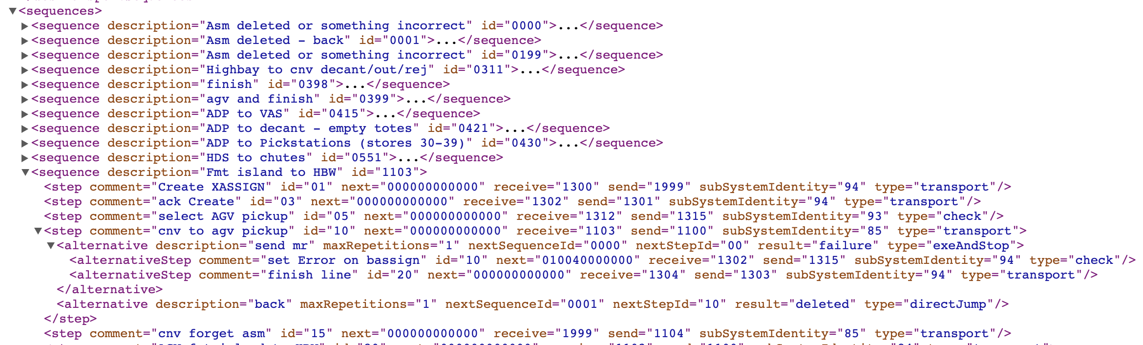
One possibility would be to use JSON, however that would be very similar to what I had and believe I can do better. I think probably a bit of typing would help both in the loading and in the understanding of the database by the developer (me), which often got confused, specially when thinking if the variable is feet, meters or inches ![]()
This latter issue may be fixed by inserting sub-types to categories. Which would also allow to use different units for the same entry.
e.g. .Altitude.Feet and .Altitude.Meters
This is a sketch of what I have right now.
% Description Gran Canarias Approach Tracon
% Space_Indentation 2
% Type_Definitions Coordinate Frequency
% Type_Definitions Icao_Airport Runway Atc_Tag
% Type_Definitions Scalar Percent Degrees Altitude.Feet Miles
% Include generic.zc
Configuration
Coordinate_Center .Coordinate 28 30 00 N 15 00 00 W
North_Degrees .Degrees 355
Atc
Clearance
Minimum_Altitude .Altitude.Feet 1000
Area
Transition_Altitude .Altitude.Feet 6500
Planes
Go_Around_Probability .Percent 5
Frequencies
%
Identifier .Frequency_Identifier UNICOM
Atc_Tag .Atc_Tag U
Frequency .Frequency_Number 121.5
%
Identifier .Frequency_Identifier CCA_CTR
Atc_Tag .Atc_Tag C
Frequency .Frequency_Number 126.5
All_Boundaries .Boolean True
%
Identifier .Frequency_Identifier TNF_S_GND
Atc_Tag .Atc_Tag G
Frequency .Frequency_Number 121.9
%
Identifier .Frequency_Identifier TNF_S_TWR
Atc_Tag .Atc_Tag ST
Frequency .Frequency_Number 119.0
Boundaries
%
Bottom_Altitude .Altitude.Feet 0
Top_Altitude .Altitude.Feet 3000
Bounds
% .Coordinate 28 06 59 N 016 34 21 W
% .Coordinate 28 06 54 N 016 35 16 W
% .Coordinate 28 06 41 N 016 36 09 W
% .Coordinate 28 06 19 N 016 36 58 W
% .Coordinate 28 05 43 N 016 37 49 W
% .Coordinate 28 05 06 N 016 38 24 W
% .Coordinate 28 04 23 N 016 38 50 W
% .Coordinate 28 03 36 N 016 39 07 W
% .Coordinate 28 02 40 N 016 39 14 W
% .Coordinate 28 01 51 N 016 39 09 W
% .Coordinate 28 01 05 N 016 38 54 W
% .Coordinate 28 00 21 N 016 38 29 W
% .Coordinate 27 59 37 N 016 37 48 W
% .Coordinate 27 59 06 N 016 37 06 W
% .Coordinate 27 58 42 N 016 36 17 W
% .Coordinate 27 58 27 N 016 35 25 W
% .Coordinate 27 58 21 N 016 34 21 W
% .Coordinate 27 58 27 N 016 33 17 W
% .Coordinate 27 58 42 N 016 32 25 W
% .Coordinate 27 59 06 N 016 31 36 W
% .Coordinate 27 59 37 N 016 30 54 W
% .Coordinate 28 00 21 N 016 30 13 W
% .Coordinate 28 01 05 N 016 29 48 W
% .Coordinate 28 01 51 N 016 29 33 W
% .Coordinate 28 02 40 N 016 29 28 W
% .Coordinate 28 03 36 N 016 29 35 W
% .Coordinate 28 04 23 N 016 29 52 W
% .Coordinate 28 05 06 N 016 30 18 W
% .Coordinate 28 05 43 N 016 30 53 W
% .Coordinate 28 06 19 N 016 31 44 W
% .Coordinate 28 06 41 N 016 32 33 W
% .Coordinate 28 06 54 N 016 33 26 W
%
Top_Altitude .Altitude.Feet 1000
Bottom_Altitude .Altitude.Feet 0
Bounds
% .Coordinate 28 02 34 N 016 47 55 W
% .Coordinate 28 01 31 N 016 47 53 W
% .Coordinate 28 00 24 N 016 47 42 W
% .Coordinate 27 59 18 N 016 47 24 W
% .Coordinate 27 57 53 N 016 46 49 W
% .Coordinate 27 55 55 N 016 45 35 W
% .Coordinate 27 54 10 N 016 43 57 W
% .Coordinate 27 52 44 N 016 41 58 W
% .Coordinate 27 51 39 N 016 39 44 W
% .Coordinate 27 50 57 N 016 37 18 W
% .Coordinate 27 50 46 N 016 36 03 W
% .Coordinate 27 50 40 N 016 34 21 W
% .Coordinate 27 50 46 N 016 32 39 W
% .Coordinate 27 50 58 N 016 31 23 W
% .Coordinate 27 51 39 N 016 28 57 W
% .Coordinate 27 52 45 N 016 26 43 W
% .Coordinate 27 54 11 N 016 24 45 W
% .Coordinate 27 55 19 N 016 23 37 W
% .Coordinate 27 56 14 N 016 22 53 W
% .Coordinate 27 58 15 N 016 21 43 W
% .Coordinate 28 00 25 N 016 21 00 W
% .Coordinate 28 01 32 N 016 20 49 W
% .Coordinate 28 02 40 N 016 20 45 W
% .Coordinate 28 03 47 N 016 20 49 W
% .Coordinate 28 04 55 N 016 20 60 W
% .Coordinate 28 06 44 N 016 21 33 W
% .Coordinate 28 08 27 N 016 22 26 W
% .Coordinate 28 10 01 N 016 23 36 W
Airports
%
ICAO_Identifier .Icao_Airport_Identifier GCTS
Spoken_Name .Spoken_Name Tenerife South
Geometry
Center .Coordinate 28 02 40 N 016 34 21 W
Altitude .Altitude.Feet 210
Frequencies
%
Short_Identifier .String TWR
Full_Identifier .Frequency_Identifier TNF_S_TWR
%
Short_Identifier .String GND
Full_Identifier .Frequency_Identifier TNF_S_GND
Runways
%
Identifier .Runway 7
Active .Boolean True
Threshold .Coordinate 28 02 21.14 N 016 35 15.50 W
End .Coordinate 28 02 59.10 N 016 33 26.43 W
Approaches
Type .Approach_Type ILS
Instrument_Fix .Waypoint_Identifier TS710
Procedures
%
Intercept_Altitude .Altitude.Feet 2500
Route .Route XANOS,3000|,$220 TS710
%
Intercept_Altitude .Altitude.Feet 2500
Route .Route KUTUR,3000| TS717,3000| TS710
Go_Around_Procedure
% alt 3000
% hold KUTUR 320 right
Charts
Departures
%
Identifier .Departure_Identifier BIMBO1W
Runway .Runway 7
Altitude .Altitude.Feet 24000
Route .Route TS506 COSSE,FL120| LUCSI KASAS BIMBO,FL200|
%
Identifier .Departure_Identifier COSSE1W
Runway .Runway 7
Altitude .Altitude.Feet 7000
Route .Route TS506 COSSE,|FL090
%
Identifier .Departure_Identifier DESUM1W
Runway .Runway 7
Altitude .Altitude.FligthLevel 240
Route .Route TS506 PELIN,FL100| GDV,FL150| SARAY DESUM
%
Identifier .Departure_Identifier GDV1P
Runway .Runway 7
Altitude .Altitude.FlightLevel 240
Route .Route TS506 PELIN,FL100| GDV,FL150|
%
Identifier .Departure_Identifier HIE1W
Runway .Runway 7
Altitude .Altitude.Feet 7000
Route .Route TS506 TS971,4000|,$210 TS972,FL070|,$230 HIE
%
Identifier .Departure_Identifier KASAS1W
Runway .Runway 7
Altitude .Altitude.FlightLevel 240
Route .Route TS506 COSSE,FL120| LUCSI KASAS
%
Identifier .Departure_Identifier KONBA1W
Runway .Runway 7
Altitude .Altitude.FlightLevel 240
Route .Route TS506 COSSE,FL120| LUCSI KASAS KONBA,FL200|
%
Identifier .Departure_Identifier KORAL1P
Runway .Runway 7
Altitude .Altitude.FlightLevel 240
Route .Route TS506 PELIN,FL100| GDV,FL150| KORAL,FL150|
%
Identifier .Departure_Identifier MOROD1W
Runway .Runway 7
Altitude .Altitude.Feet 7000
Route .Route TS506 TS971,4000|,$210 TS972,5000|5000,$230 TS901,5000|5000 MOROD,|FL070
%
Identifier .Departure_Identifier ODEGI2W
Runway .Runway 7
Altitude .Altitude.Feet 7000
Route .Route TS506 QITTI,|FL070 MATUD ODEGI,FL200|
%
Identifier .Departure_Identifier PELIN2W
Runway .Runway 7
Altitude .Altitude.Feet 9000
Route .Route TS506 PELIN,|FL090
%
Identifier .Departure_Identifier RASEP1W
Runway .Runway 7
Altitude .Altitude.Feet 24000
Route .Route TS506 PELIN,FL100| GDV,FL150| RASEP
%
Identifier .Departure_Identifier REMGI2W
Runway .Runway 7
Altitude .Altitude.Feet 7000
Route .Route TS506 QITTI,|FL070 REMGI,FL150|
%
Identifier .Departure_Identifier VASTO1W
Runway .Runway 7
Altitude .Altitude.Feet 24000
Route .Route TS506 PELIN,FL100| GDV,FL150| SARAY VASTO,FL200|
Arrivals
%
Identifier .Departure_Identifier ESOPA2Y
Runway .Runway 7
Altitude .Altitude.Feet 3000
Route .Route ESOPA LUFIR,$250,293<250 TS568 QITTI TS559,FL090| FEMMA,252<250 LULUG,6000|FL100,220$220,251<220 TS748,4000|FL070 TS746,3000| TS744 TS742 TS731 TS726 TS721 XANOS,3000|,072>220
%
Identifier .Departure_Identifier HIE2Y
Runway .Runway 7
Altitude .Altitude.Feet 3000
Route .Route HIE,FL150| BOXCO,$250 YEQAY,FL110|,125>250 ICAFU,FL080|FL100,220$220,129>220 TS769,6000|FL070 TS767,4000| TS765,3000| TS763 TS731 TS726 TS721 XANOS,3000|,072>220
%
Identifier .Departure_Identifier KONBA2X
Runway .Runway 7
Altitude .Altitude.Feet 3000
Route .Route KONBA,FL200| BRICK ARACO BOXCO,$250 YEQAY,FL110|,125>250 ICAFU,FL080|FL100,220$220,129>220 TS769,6000|FL070 TS767,4000| TS765,3000| TS763 TS731 TS726 TS721 XANOS,3000|,072>220
%
Identifier .Departure_Identifier LOMAS2Y
Runway .Runway 7
Altitude .Altitude.Feet 3000
Route .Route LOMAS QITTI,$250 TS559,FL090| FEMMA,252<250 LULUG,6000|FL100,220$220,251<220 TS748,4000|FL070 TS746,3000| TS744 TS742 TS731 TS726 TS721 XANOS,3000|,072>220
%
Identifier .Departure_Identifier LORPO2Y
Runway .Runway 7
Altitude .Altitude.Feet 3000
Route .Route LORPO LPC,293<250 QITTI,$250 TS559,FL090| FEMMA,252<250 LULUG,6000|FL100,220$220,251<220 TS748,4000|FL070 TS746,3000| TS744 TS742 TS731 TS726 TS721 XANOS,3000|,072>220
%
Identifier .Departure_Identifier ODEGI2Y
Runway .Runway 7
Altitude .Altitude.Feet 3000
Route .Route ODEGI,FL110| FEMMA,$250 LULUG,6000|FL100,220$220,251<220 TS748,4000|FL070 TS746,3000| TS744 TS742 TS731 TS726 TS721 XANOS,3000|,072>220
%
Identifier .Departure_Identifier ORTIS2X
Runway .Runway 7
Altitude .Altitude.Feet 3000
Route .Route ORTIS,FL110| BRICK ARACO BOXCO,$250 YEQAY,FL110|,125>250 ICAFU,FL080|FL100,220$220,129>220 TS769,6000|FL070 TS767,4000| TS765,3000| TS763 TS731 TS726 TS721 XANOS,3000|,072>220
%
Identifier .Departure_Identifier REMGI2Y
Runway .Runway 7
Altitude .Altitude.Feet 3000
Route .Route REMGI,FL100| LOMAS QITTI,$250 TS559,FL090| FEMMA,252<250 LULUG,6000|FL100,220$220,251<220 TS748,4000|FL070 TS746,3000| TS744 TS742 TS731 TS726 TS721 XANOS,3000|,072>220
%
Identifier .Departure_Identifier RUSIK2K
Runway .Runway 7
Altitude .Altitude.Feet 3000
Route .Route RUSIK CANIS LPC,293<250 QITTI,$250 TS559,FL090| FEMMA,252<250 LULUG,6000|FL100,220$220 TS748,4000|FL070 TS746,3000| TS744 TS742 TS731 TS726 TS721 XANOS,3000|,072>220
%
Identifier .Departure_Identifier TERTO2Y
Runway .Runway 7
Altitude .Altitude.Feet 3000
Route .Route TERTO,FL100| CANIS LPC,293<250 QITTI,250$250 TS559,FL090| FEMMA,252<250 LULUG,6000|FL100,220$220 TS748,4000|FL070 TS746,3000| TS744 TS742 TS731 TS726 TS721 XANOS,3000|,072>220
%
Identifier .Departure_Identifier URQUI2Y
Runway .Runway 7
Altitude .Altitude.Feet 3000
Route .Route URQUI,FL100| LULUG,6000|FL100,220$220 TS748,4000|FL070 TS746,3000| TS744 TS742 TS731 TS726 TS721 XANOS,3000|,072>220
%
Identifier .Departure_Identifier VIZON2Y
Runway .Runway 7
Altitude .Altitude.Feet 3000
Route .Route VIZON TS748,4000|FL070,$220 TS746,3000| TS744 TS742 TS731 TS726 TS721 XANOS,3000|,072>220
%
Identifier .Departure_Identifier YEQAY2Y
Runway .Runway 7
Altitude .Altitude.Feet 3000
Route .Route YEQAY,FL110|,125>250 ICAFU,FL080|FL100,220$220,129>220 TS769,6000|FL070 TS767,4000| TS765,3000| TS763 TS731 TS726 TS721 XANOS,3000|,072>220
%
Identifier .Departure_Identifier YELBE1Y
Runway .Runway 7
Altitude .Altitude.Feet 3000
Route .Route YELBE,091>220 TS731,3000|,$220 TS726 TS721 XANOS,3000|,072>220
Waypoints
%
Identifier .Waypoint_Identifier GDV
Spoken_Name .Spoken_Name Gran Canaria
Kind .Waypoint_Kind VOR
Coordinate .Coordinate 28 04 37.5 N 015 25 44.4 W
%
Identifier .Waypoint_Identifier HIE
Spoken_Name .Spoken_Name El Hierro
Kind .Waypoint_Kind VOR
Coordinate .Coordinate 27 48 58.2 N 017 53 11.0 W
%
Identifier .Waypoint_Identifier LPC
Spoken_Name .Spoken_Name Gran Canarias South
Kind .Waypoint_Kind VOR IAF
Coordinate .Coordinate 27 49 42.7 N 015 25 56.1 W
%
Identifier .Waypoint_Identifier TFN
Spoken_Name .Spoken_Name Tenerife North
Kind .Waypoint_Kind VOR IAF
Coordinate .Coordinate 28 32 12.9 N 016 16 07.2 W
%
Identifier .Waypoint_Identifier TFS
Spoken_Name .Spoken_Name Tenerife South
Kind .Waypoint_Kind VOR IAF
Coordinate .Coordinate 28 00 08.8 N 016 41 15.0 W
%
Identifier .Waypoint_Identifier LRO
Spoken_Name .Spoken_Name Los Rodeos
Kind .Waypoint_Kind VOR
Coordinate .Coordinate 28 29 05.7 N 016 21 05.6 W
%
Identifier .Waypoint_Identifier FTV
Spoken_Name .Spoken_Name Fuerte Ventura
Kind .Waypoint_Kind VOR
Coordinate .Coordinate 28 25 51 N 013 51 52 W
%
Identifier .Waypoint_Identifier LZR
Spoken_Name .Spoken_Name Lanzarote
Kind .Waypoint_Kind VOR
Coordinate .Coordinate 29 09 58 N 013 30 39 W
%
Identifier .Waypoint_Identifier LTE
Spoken_Name .Spoken_Name Lanzarote Airport
Kind .Waypoint_Kind VOR IAF
Coordinate .Coordinate 28 56 53 N 013 36 05 W
%
Identifier .Waypoint_Identifier BABNA
Spoken_Name .Spoken_Name Babna
Kind .Waypoint_Kind FIX
Coordinate .Coordinate 30 00 43 N 010 10 15 W
%
Identifier .Waypoint_Identifier VEDOD
Spoken_Name .Spoken_Name Vedod
Kind .Waypoint_Kind FIX
Coordinate .Coordinate 30 30 21 N 012 22 24 W
%
Identifier .Waypoint_Identifier SULAM
Spoken_Name .Spoken_Name Sulam
Kind .Waypoint_Kind FIX
Coordinate .Coordinate 30 54 57 N 013 14 54 W
%
Identifier .Waypoint_Identifier MITLA
Spoken_Name .Spoken_Name Mitla
Kind .Waypoint_Kind FIX
Coordinate .Coordinate 31 18 30 N 014 04 56 W
%
Identifier .Waypoint_Identifier SONSO
Spoken_Name .Spoken_Name Sonso
Kind .Waypoint_Kind FIX
Coordinate .Coordinate 30 00 44 N 012 06 07 W
%
Identifier .Waypoint_Identifier ADOKI
Spoken_Name .Spoken_Name Adoki
Kind .Waypoint_Kind FIX IAF
Coordinate .Coordinate 27 43 55.9 N 015 25 46.4 W
%
Identifier .Waypoint_Identifier ADOVO
Spoken_Name .Spoken_Name Adovo
Kind .Waypoint_Kind FIX
Coordinate .Coordinate 28 34 05 N 013 47 42 W
%
Identifier .Waypoint_Identifier ALEDU
Spoken_Name .Spoken_Name Aledu
Kind .Waypoint_Kind FIX
Coordinate .Coordinate 28 54 07.0 N 013 20 41.1 W
%
Identifier .Waypoint_Identifier ALUGO
Spoken_Name .Spoken_Name Alugo
Kind .Waypoint_Kind FIX
Coordinate .Coordinate 29 28 08 N 013 00 38 W
%
Identifier .Waypoint_Identifier ARACO
Spoken_Name .Spoken_Name Araco
Kind .Waypoint_Kind FIX
Coordinate .Coordinate 28 25 57.1 N 017 27 08.4 W
%
Identifier .Waypoint_Identifier ARTEM
Spoken_Name .Spoken_Name Artem
Kind .Waypoint_Kind FIX
Coordinate .Coordinate 28 24 33 N 016 02 03 W
%
Identifier .Waypoint_Identifier ASTAM
Spoken_Name .Spoken_Name Astam
Kind .Waypoint_Kind FIX
Coordinate .Coordinate 28 58 52.3 N 013 18 52.8 W
%
Identifier .Waypoint_Identifier BAFEM
Spoken_Name .Spoken_Name Bafem
Kind .Waypoint_Kind FIX IAF
Coordinate .Coordinate 27 49 51.6 N 015 09 09.0 W
%
Identifier .Waypoint_Identifier BAMKU
Spoken_Name .Spoken_Name Bamku
Kind .Waypoint_Kind FIX
Coordinate .Coordinate 28 22 46.3 N 013 43 44.6 W
%
Identifier .Waypoint_Identifier BAPAL
Spoken_Name .Spoken_Name Bapal
Kind .Waypoint_Kind FIX IAF
Coordinate .Coordinate 28 41 16.5 N 013 25 45.5 W
Positions
%
Name .String tnfs
Scope
Range .Miles 35
Rings
Spacing .Miles 10
Center .Coordinate 28 02 40 N 016 34 21 W
Filter
Primary
Minimum .Altitude.Feet 1000
Maximum .Altitude.Feet 16000
Secondary
Minimum .Altitude.Feet 500
Maximum .Altitude.Feet 24000
Frequencies
Slot_0
Frequency .Frequency_Identifier TNF_SOUTH_APP
Slot_1
Frequency .Frequency_Identifier UNICOM
Atis
% .ICAO_Airport GCTS
% .ICAO_Airport GCXO
% .ICAO_Airport GCLP
% .ICAO_Airport GCFV
% .ICAO_Airport GCRR
% .ICAO_Airport GCHI
% .ICAO_Airport GCLA
Thanks in advance
–zen
For reference, here goes a gameplay example of the C version